


Vom Genfersee an den Bodensee

My Switzerland
Optez pour le retour à la nature GUIDE+
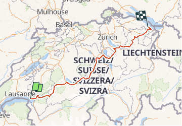

Length
302 km

Max alt
1589 m

Uphill gradient
12305 m
Km-Effort
466 km

Min alt
391 m

Downhill gradient
12302 m
Boucle
No
Creation date :
2014-12-10 00:00:00.0
Updated on :
2014-12-10 00:00:00.0
123h06
Difficulty : Unknown

FREE GPS app for hiking
 SityTrail
IGN / Geographical institutes
SityTrail Plus
The world is yours!
About
Trail Cycle of 302 km to be discovered at Vaud, District de la Riviera-Pays-d’Enhaut, La Tour-de-Peilz. This trail is proposed by My Switzerland.
Positioning
Country:
Switzerland
Region :
Vaud
Department/Province :
District de la Riviera-Pays-d’Enhaut
Municipality :
La Tour-de-Peilz
Location:
Unknown
Start:(Dec)
Start:(UTM)
336048 ; 5146421 (32T) N.
Comments